Geometric rose logo
  • Numbers like π\piπ and 2\sqrt{2}2​ are irrational. Are they called that because they are unreasonable? Or is it just because they just can’t be expressed as a ratio of two integers?

    As it turns out, this question is even harder to answer in Ancient Greek. On the one hand, the word used by (e.g.) Euclid to describe irrational lengths (ἄλογος) comes from adding the negative prefix ἄ- to the word for ratio (λόγος). On the other hand, λόγος and ἄλογος had a lot of other meanings.

    Ἄλογος could mean unexpected, which would be an appropriate description of the newly-discovered irrational numbers. Or it could mean unspeakable — in the literal sense, although the figurative sense fits with the (possibly fictitious) cover-up by the Pythagoreans. The word could also mean speechless or incapable of reasoning.

    It’s fascinating to see how translators (and later mathematicians) decided to resolve the polysemy of ἄλογος:

    • Latin translations of Greek works used ratio for λόγος and irrationalis for ἄλογος. These were actually imported into mathematical English before their non-technical meanings.
    • Early Arabic mathematicians called 2\sqrt{2}2​ a deaf root (جذر أصم) in reference to the “speechless” meaning of ἄλογος. This got translated back to Latin as surd, a now-archaic term for (irreducible) roots.
    • In modern Arabic, the phrase is “non-fractional number” (عدد غير كسري).
    • In modern Greek, irrational numbers are now called inexpressible (άρρητος).
    2025-02-27
  • Today is National Day for Truth and Reconciliation in Canada. With the day off comes an opportunity (and responsibility) to learn about residential schools, through which the federal government and Canadian churches separated children from their families and subjected them to abuse and neglect in loco parentis.

    [R]econciliation, in the context of Indian residential schools, is similar to dealing with a situation of family violence.

    Honouring the Truth, Reconciling for the Future
    Truth and Reconciliation Commission of Canada

    Although the first residential schools were first established pre-Confederation, their story is shockingly and depressingly recent: residential school populations were at their highest from the 1920s to the 1960s, and some continued to operate well into my own childhood.

    2024-09-30
  • The Kama Sutra (कामसूत्र) is an ancient Hindu text about sensory pleasure. Although it’s best known in English for its most risqué chapters, it also contains a list of sixty-four arts whose knowledge makes a person popular and attractive.

    1. Singing.
    2. Playing on musical instruments.
    3. Dancing.
    …
    28. A game, which consisted in repeating verses, and as one person finished, another person had to commence at once, repeating another verse, beginning with the same letter with which the last speaker’s verse ended, whoever failed to repeat was considered to have lost

    Kama Sutra, Chapter 3

    In modern times, the twenty-eighth art is primarily practiced by bored children on road trips and is known by many names like word chain or shiritori. I had no idea it was over 1700 years old!

    2024-09-25
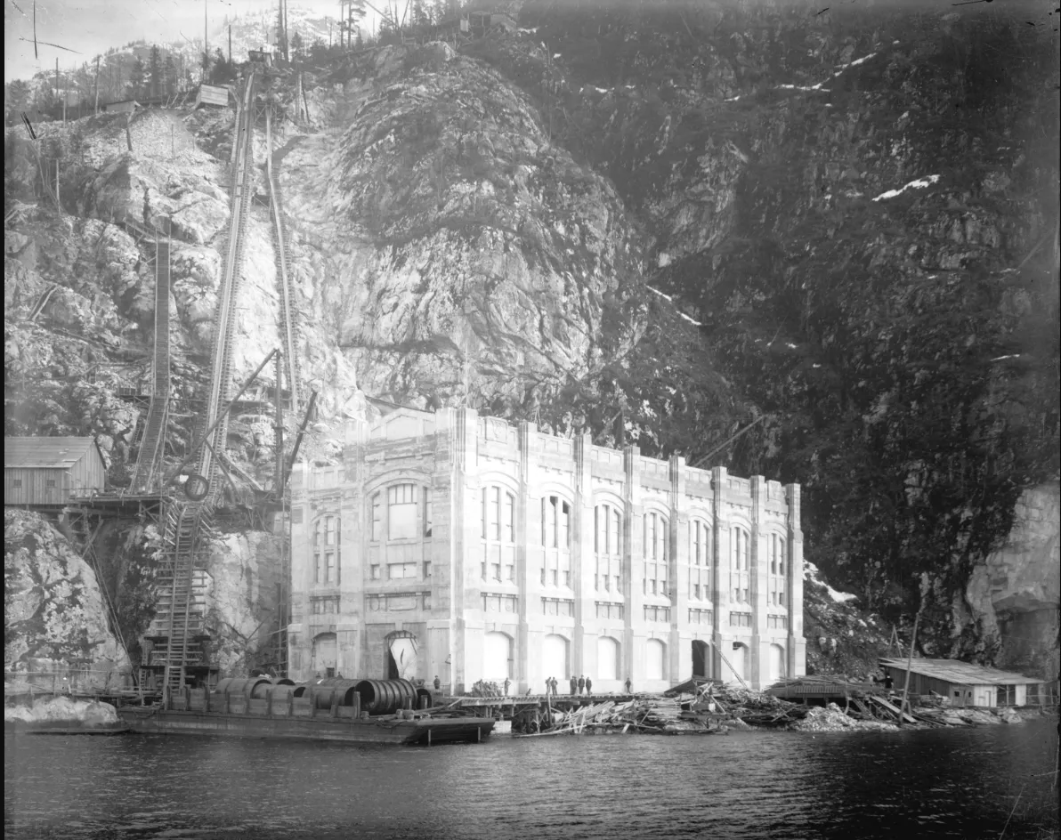
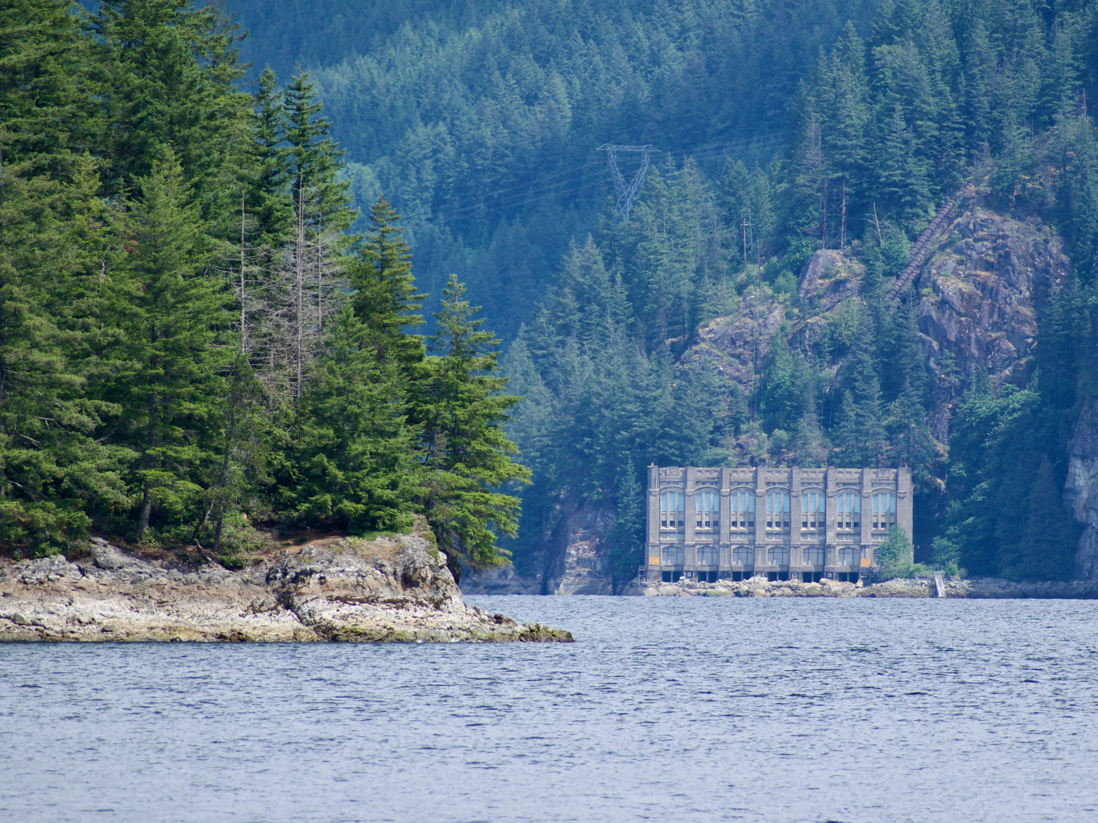
  • A large rectangular concrete building sits on the water at the base of a forested mountain

    I recently went for a walk in təmtəmíxʷtən (Belcarra), and when I got to… wait, what’s that weird derelict building in the distance?


    Is it an abandoned hotel? No, there’s no way to get there by land. An old naval fortress? No, the location doesn’t make any strategic sense. A hydroelectric dam? Where’s the water behind it?

    As it turns out, it is a power plant! Buntzen generating station #2, completed in 1914, was built to supplement the output of BC’s first-ever hydroelectric plant up-inlet. Both stations were powered by water delivered by penstocks from Buntzen Lake, which in turn was supplied with water from Coquitlam Lake via a 4km-long tunnel.

    Buntzen station #1 is still functional and supplies 60 megawatts of power to the Metro Vancouver area. Buntzen #2 was shut down at the turn of the millennium and serves as a historic curiosity for kayakers in səl̓ilw̓ət (Indian Arm).

    A black-and-white photo of a large but narrow concrete building at the bottom of a steep hill on the water

    Buntzen station #2 under construction in 1913. (James Matthews/Vancouver Archives)

    2024-05-06
  • Today I learned the reason why Vancouver has two impressive-looking historic train stations: they were built by two different companies to serve as the terminus of two different railways.

    Waterfront station was built in 1914 for the Canadian Pacific Railway, while Pacific Central Station was built a few years later for the Canadian Northern Railway.1

    Anyways, neither station is currently used by the company that built it, with Waterfront Station serving as the regional public transit hub and Pacific Central Station used by Via Rail, Amtrak, and various intercity bus companies.

    1. Canadian Northern was nationalized as Canadian National Railways, then privatized as CN, and now apparently Bill Gates is the company’s largest shareholder? I did not expect that.

    2023-08-13
  • Julius Caesar’s given name wasn’t “Julius”. That was his full family name — the Caesars being a branch of the Julia family — and his personal name was Gaius.

    In his time, he was referred to as Gaius Caesar or simply as Caesar by himself and his contemporaries. Calling him “Julius Caesar” would have been redundant since every Caesar was a Julius.

    The Romans had a lot of traditions around names. Gaius Julius Caesar inherited his name from his father, grandfather, and great-grandfather.

    Caesar’s great-nephew Gaius Octavius Thurinus also took the name Gaius Julius Caesar when he inherited the assassinated dictator’s estate. To prevent confusion, he’s often called Octavianus, meaning “the guy formerly known as Octavius”. The emperor Caligula, Octavian’s great-grandson, was also named Gaius Caesar; we know him by a nickname he received as a small child.

    2023-06-30
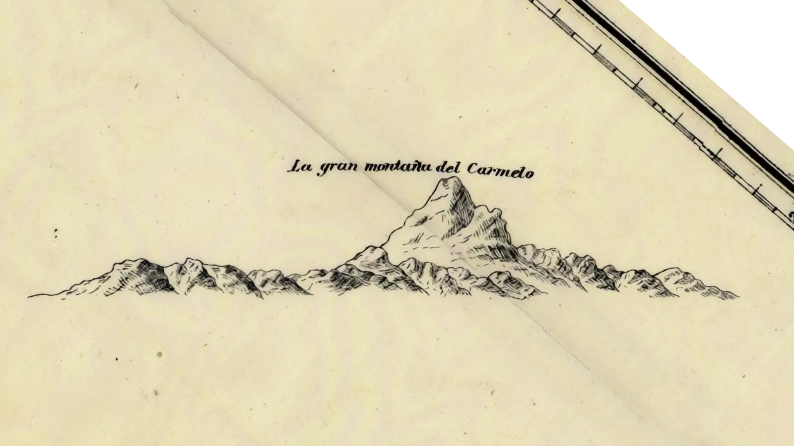
  • A mountain labeled "La gran montaña de Carmelo" drawn on a historic map

    Mount Baker was named by George Vancouver after his third lieutenant, who was the first on his ship to see it.

    Although the name is better than a few others in the Pacific Northwest, being the first person to see a giant mountain isn’t a particularly notable claim to fame. Especially when you have to ignore not only tens of thousands of people who lived there but also the Spaniards who had gotten there the year prior.


    The mountain appears as la gran montaña del Carmelo on a map drawn by Gonzalo Lopez de Haro, first pilot on Manuel Quimper’s six-week expedition to the Juan de Fuca strait. The Spanish name is apparently a reference to a religious order whose white cloaks resembled the snow-capped peak. Who knows, if the Nootka Crisis had been resolved differently, it’s entirely possible that Europeans would have ended up calling it Monte Carmelo.

    Instead, the name Mount Baker stuck after Vancouver described it in his published memoir.

    About this time a very high conspicuous craggy mountain … presented itself, towering above the clouds: as low down as they allowed it to be visible it was covered with snow; and south of it, was a long ridge of very rugged snowy mountains, much less elevated, which seemed to stretch to a considerable distance … the high distant land formed, as already observed, like detached islands, amongst which the lofty mountain, discovered in the afternoon by the third lieutenant, and in compliment to him called by me Mount Baker, rose a very conspicuous object … apparently at a very remote distance.

    George Vancouver

    Vancouver’s diary mentions encounters with different indigenous groups of the area, some friendly and some indifferent,1 but he never stuck around in the same place long enough to learn their names or pick up their languages.2 If he had, he might have recognized Mount Baker by the name kwelshan, the term used by the Lhaq’temish (Lummi) people around Bellingham and the San Juan Islands, or swáʔləx̣, reportedly used by the nəxʷsƛ̕áy̕əm̕ (Klallam) people on the Olympic Peninsula.

    The mountain itself is surrounded by the traditional lands of the Nooksack and Upper Skagit peoples. The Nooksack use kwelshán for the high open slopes of the mountain and kweq’ smánit for the glacier-covered summit.

    1. George Vancouver recorded people who “seemed to view us with the utmost indifference and unconcern… as if such vessels had been familiar to them, and unworthy of their attention”, which might have tipped him off that the Spanish had beaten him to the area. Instead, he wrote that he had “advanced further up this inlet than… any other person from the civilized world [sic]”.

    2. Vancouver claimed that his crew had “some knowledge of” nuučaan̓uɫ from the Island’s west coast, but that’s from a different language family from the Salishan languages spoken around the strait.

    2017-12-25
  • When the Ontario cities of Fort William and Port Arthur amalgamated in 1970, residents voted for a new name for their new city.

    Candidate nameVotes
    Thunder Bay15,870
    Lakehead15,302
    The Lakehead8,377

    The result deserves a place of honour in voting theory textbooks.

    2013-02-20
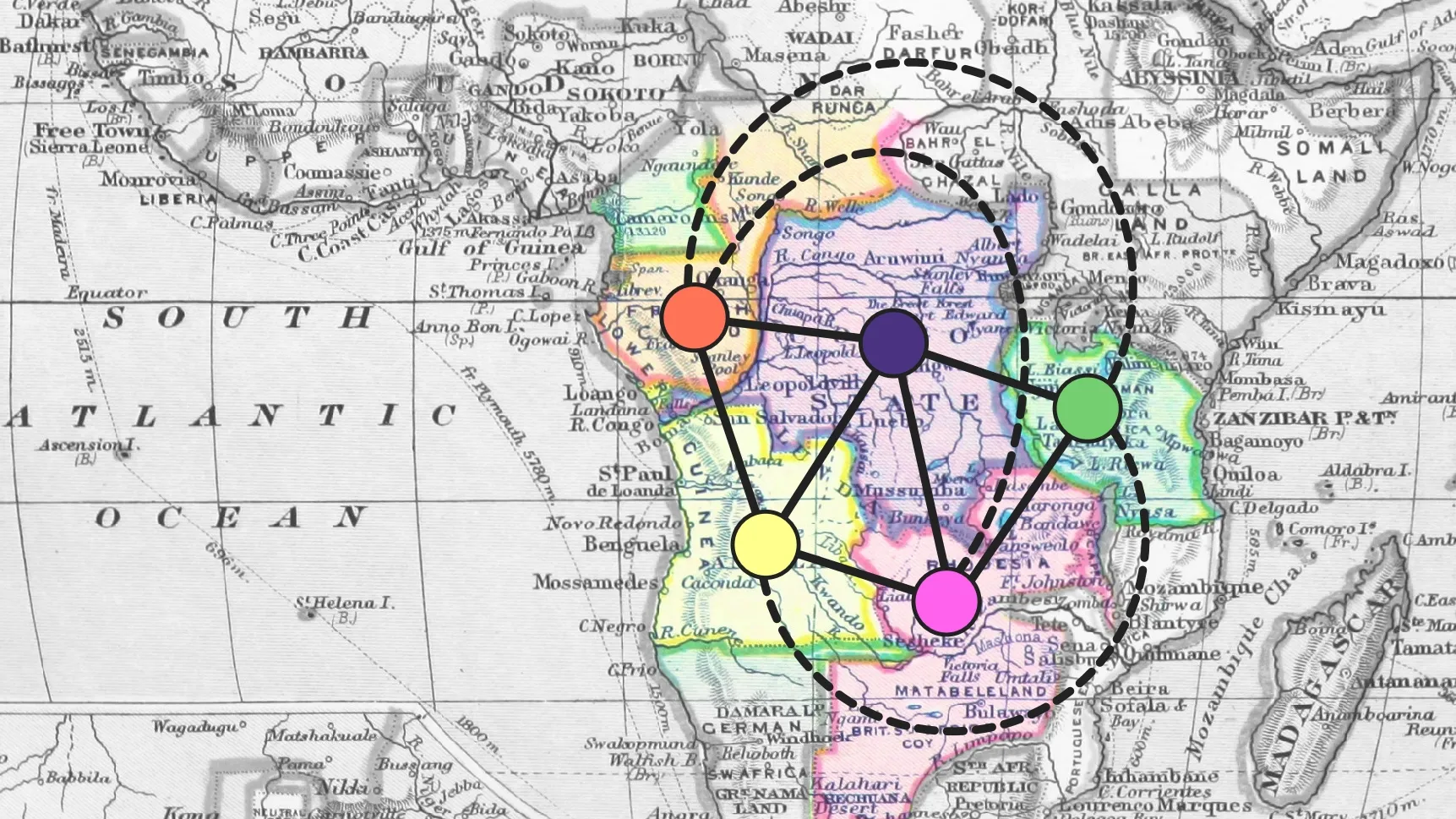
  • A historical map of Africa, with an overlaid diagram showing adjacencies between European claims

    In 1852, then-student Francis Guthrie wondered any if possible map required more than four colours. By the end of the century, Guthrie and his fellow colonists had drawn a map on Africa that needed five.


    The Four-Colour Theorem says that, no matter what the borders on your map are, you only need four colours to make sure that neighbouring regions are coloured differently. The theorem doesn’t apply if you let some regions claim other disconnected regions as their own, and in fact the map of European claims on Africa required five colours by the end of the 19th century.

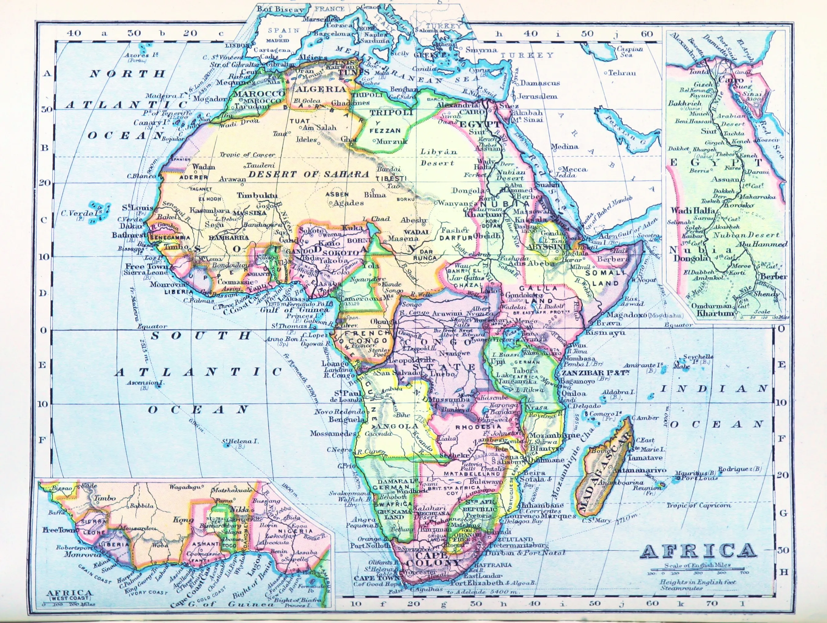
    A British map of Africa published in 1899

    A map of Africa published in 1899. (William Balfour Irvine / British Library)

    Francis Guthrie, who moved to the South African Cape Colony in 1861, could well have owned a map like the above. Five colours are necessary to properly colour the land that Britain (red), France (orange), Portugal (yellow), Germany (green), and Belgium’s King Leopold II (purple) decided should belong to them.

    Five territorities in the center are key to the map colouring:

    AreaColonizer
    🟣Congo basinKing Leopold II
    🟠north of the CongoFrance
    🟡south of the KwangoPortugal
    🔴upper Zambezi basinBritain
    🟢African Great LakesGermany

    The boundaries between these colonies separate seven different pairs of empires. Borders between other African colonies account for the other three possible sets of neighbours:

    • French Congo was next to German Kamerun;
    • German East Africa to Portuguese Mozambique; and
    • French claims in the Ubangi-Chari area were next to Anglo-Egyption Sudan.

    In short, the adjacency graph between these empires was the complete graph K5K_5K5​.

    2012-07-31
© 2007–2025 Ross Churchley